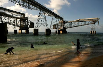
Nauru. Phosphate loading mechanism
Sea Life 1952. Tynebank Nauru Island.
First draft
We left Sydney after bunkering, with our orders to sail for Nauru Island roughly 2200 nautical miles away, almost on the equator and roughly NE of the Solomon Islands. The journey at our best speed of 6.5 knots would take us around 15days. We steamed in a north-easterly direction and crossing the Tropic of Capricorn, we passed into the Coral Sea. Then through the gap between the Solomon Islands and Vanuatu (which in 1952 was called the New Hebrides), we now had a relatively short run to Nauru. As was my usual practise when we were a 2 days or so from our destination I radioed our EST to the little coast station.
Soon we got our first glimpse of Nauru, a haze of greenery from the palm trees on the coastal strip and then the pylons of the loading ramps as pictured above of the phosphate loader. The concrete and steel pylons stretch out into the sea to the coral reef edge where the reef drops sharply into deep water. At this point a telescopic heavy duty flying lattice arm protrudes over the deep water to which the ship ties up.
On top of this lattice work runs a conveyor belt which carries the crushed phosphate rock from shore. The phosphate then pours into a long swivelled metal tube which in turn guides and pours the phosphate into each of the ships holds in turn.
The phosphates were seabird droppings, known as guano, deposited on the coral island over millions of years which slowly over time turned into phosphate rock.
The loading of the Tynebank took 36 hours, I think. I didn’t go ashore here. Nauru is not a very nice place as we shall see below. Although when looking into the deep crystal clear water over the ships side, the view was beautiful, full of both multicoloured coral and fish and when nearer to shore, plant life. The shoreline when viewed along the length was pleasant, too with swaying palms and white sandy beaches. The ugly part of Nauru was the centre of the island.
In 1970s and 80s Nauru was favoured by scuba divers and spear fishermen in the deep water of the edge of the reef.
The following is a short description of the island which I found, trawling on Google.
Nauru, once called the Pleasant Island, is nowadays far from being a paradise. Nauruan’s have lost their little island, severely devastated by mining, and face an uncertain future even as a nation. Some would blame original exploiters
for environmental disaster (Great Britain, Australia, etc.) as they mined out about2/3rds of the phosphates. But the truth is that after becoming an independent republic Nauru kept on mining the phosphates until recent exhaustion.
When we were fully loaded we headed back to Australia and our ports of call were to be Brisbane and then Port Kembla, just south of Sydney.
Nauru, once called the Pleasant Island, is nowadays far from being a paradise. Nauruan’s have lost their little island, severely devastated by mining, and face an uncertain future even as a nation. Some would blame original exploiters for environmental disaster (Great Britain, Australia, etc.) as they mined out about 2/3 of the phosphates. But the truth is that after becoming an independent republic Nauru kept on mining the phosphates until recent exhaustion.
Nauru island 8 sq. miles


No comments:
Post a Comment